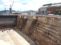
Selborne Graving Dock
Appearance
| Selborne Graving Dock | |
|---|---|
 | |
| General information | |
| Type | Dry dock |
| Architectural style | Graving |
| Location | Naval Base Simon's Town, Simon's Town, Western Cape, South Africa |
| Coordinates | 34°11′31″S 18°26′24″E / 34.19194°S 18.44000°E |
| Construction started | 15 November 1906 |
| Inaugurated | 3 November 1910 |
| Client | British Admiralty |
| Owner | Department of Defence (South Africa) |
| Design and construction | |
| Main contractor | Sir John Jackson Ltd |
The Selborne Graving Dock is a dry dock in Simon's Town, South Africa. It is situated within the Naval Base Simon's Town. It is named for William Palmer, 2nd Earl of Selborne, the High Commissioner for Southern Africa at the time of construction.
History
[edit]On 27 July 1900[1] a tender for the construction of a yard was awarded to Sir John Jackson Ltd. The construction used Portland cement from England, as well as granite blocks from Norway. The foundation stone was laid on 15 November 1906, and the dry dock was opened on 3 November 1910,[1] by the Duke of Connaught.[2]
The Dockyard (including the dry dock) was handed to South Africa in 1957,[1][3] as part of the Simonstown Agreement.
Images
[edit]-
Construction in 1906
-
The ships crests painted on the wall
-
The dock split to allow two ships to enter
References
[edit]- ^ a b c "Naval Dockyard celebrates centenary". defenceWeb.co.za. 4 November 2010. Retrieved 14 May 2017.
- ^ "Opening of Selborne Graving Dock". Wanganui Chronicle. Vol. L, no. 12652. 4 November 1910. p. 5. Retrieved 18 February 2014.
- ^ Robson, Linda Gillian (2011). The Royal Engineers and settlement planning in the Cape Colony 1806–1872: Approach, methodology and impact (PhD thesis). Pretoria: University of Pretoria. p. 109. hdl:2263/26503.
Wikimedia Commons has media related to Selborne Graving Dock.


